|
|
|||||||||||||||||
| Point ID: 62 | Downloads | Plots | Site Data | Code: 05AC012 |
|
|
|||||||||||||||||
| Download | |
|---|---|
| Site Descriptor Information | Site Time Series Data |
| Link to all available data | |
| View: | Time Series | All |
| Units: | mm |
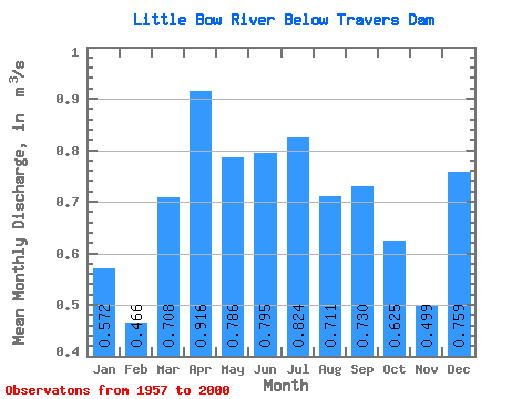
| Statistic | Jan | Feb | Mar | Apr | May | Jun | Jul | Aug | Sep | Oct | Nov | Dec | Annual |
|---|---|---|---|---|---|---|---|---|---|---|---|---|---|
| Mean | 0.57 | 0.47 | 0.71 | 0.92 | 0.79 | 0.80 | 0.82 | 0.71 | 0.73 | 0.62 | 0.50 | 0.76 | 0.46 |
| Standard Deviation | 0.90 | 0.26 | 0.97 | 1.05 | 0.50 | 0.48 | 0.66 | 0.54 | 0.51 | 0.35 | 0.41 | 1.45 | 0.15 |
| Min | 0.14 | 0.25 | 0.10 | 0.18 | 0.23 | 0.26 | 0.18 | 0.22 | 0.22 | 0.23 | 0.19 | 0.13 | 0.28 |
| Max | 3.53 | 1.06 | 4.17 | 5.25 | 2.51 | 3.18 | 3.81 | 3.52 | 2.30 | 1.93 | 1.69 | 5.54 | 0.76 |
| Coefficient of Variation | 1.58 | 0.56 | 1.38 | 1.15 | 0.64 | 0.60 | 0.80 | 0.77 | 0.70 | 0.55 | 0.82 | 1.91 | 0.33 |
 Return to R-Arctic Net Home Page