|
|
|||||||||||||||||
| Point ID: 618 | Downloads | Plots | Site Data | Code: 07AF009 |
|
|
|||||||||||||||||
| Download | |
|---|---|
| Site Descriptor Information | Site Time Series Data |
| Link to all available data | |
| View: | Time Series | All |
| Units: | mm |
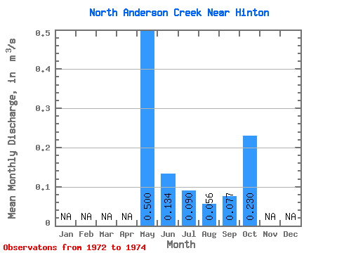
| Statistic | Jan | Feb | Mar | Apr | May | Jun | Jul | Aug | Sep | Oct | Nov | Dec | Annual |
|---|---|---|---|---|---|---|---|---|---|---|---|---|---|
| Mean | 0.50 | 0.13 | 0.09 | 0.06 | 0.08 | 0.23 | |||||||
| Standard Deviation | 0.04 | 0.07 | 0.04 | 0.01 | 0.06 | ||||||||
| Min | 0.47 | 0.09 | 0.07 | 0.04 | 0.04 | 0.23 | |||||||
| Max | 0.53 | 0.18 | 0.13 | 0.07 | 0.12 | 0.23 | |||||||
| Coefficient of Variation | 0.09 | 0.51 | 0.39 | 0.23 | 0.77 |
 Return to R-Arctic Net Home Page