|
|
|||||||||||||||||
| Point ID: 6150 | Downloads | Plots | Site Data | Code: 3057 |
|
|
|||||||||||||||||
| Download | |
|---|---|
| Site Descriptor Information | Site Time Series Data |
| Link to all available data | |
| View: | Time Series | All |
| Units: | mm |
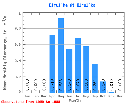
| Statistic | Jan | Feb | Mar | Apr | May | Jun | Jul | Aug | Sep | Oct | Nov | Dec | Annual |
|---|---|---|---|---|---|---|---|---|---|---|---|---|---|
| Mean | 0.00 | 0.00 | 0.00 | 0.72 | 0.93 | 0.54 | 0.68 | 0.58 | 0.36 | 0.14 | 0.01 | 0.00 | 0.33 |
| Standard Deviation | 0.00 | 0.00 | 0.00 | 0.79 | 0.69 | 0.45 | 0.80 | 0.90 | 0.41 | 0.16 | 0.02 | 0.00 | 0.20 |
| Min | 0.00 | 0.00 | 0.00 | 0.02 | 0.02 | 0.04 | 0.00 | 0.01 | 0.02 | 0.01 | 0.00 | 0.00 | 0.04 |
| Max | 0.00 | 0.00 | 0.00 | 4.05 | 2.54 | 2.10 | 3.70 | 4.83 | 1.65 | 0.78 | 0.11 | 0.00 | 0.94 |
| Coefficient of Variation | 1.10 | 0.75 | 0.84 | 1.18 | 1.55 | 1.15 | 1.13 | 1.97 | 0.60 |
 Return to R-Arctic Net Home Page