|
|
|||||||||||||||||
| Point ID: 6147 | Downloads | Plots | Site Data | Code: 3042 |
|
|
|||||||||||||||||
| Download | |
|---|---|
| Site Descriptor Information | Site Time Series Data |
| Link to all available data | |
| View: | Time Series | All |
| Units: | mm |
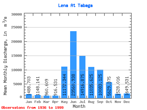
| Statistic | Jan | Feb | Mar | Apr | May | Jun | Jul | Aug | Sep | Oct | Nov | Dec | Annual |
|---|---|---|---|---|---|---|---|---|---|---|---|---|---|
| Mean | 1488.70 | 1148.14 | 960.61 | 916.53 | 11172.34 | 23560.94 | 14916.88 | 11035.62 | 10083.12 | 5629.38 | 1528.02 | 1649.53 | 7007.48 |
| Standard Deviation | 332.60 | 242.07 | 185.79 | 185.97 | 3646.79 | 5408.30 | 4418.60 | 3695.04 | 3460.34 | 1511.51 | 359.57 | 330.26 | 1141.08 |
| Min | 817.00 | 667.00 | 607.00 | 647.00 | 3390.00 | 10500.00 | 7220.00 | 4350.00 | 4690.00 | 3020.00 | 901.00 | 1010.00 | 5026.75 |
| Max | 2410.00 | 1780.00 | 1480.00 | 1590.00 | 21000.00 | 35900.00 | 25600.00 | 22800.00 | 20700.00 | 9670.00 | 2270.00 | 2520.00 | 10510.83 |
| Coefficient of Variation | 0.22 | 0.21 | 0.19 | 0.20 | 0.33 | 0.23 | 0.30 | 0.34 | 0.34 | 0.27 | 0.23 | 0.20 | 0.16 |
 Return to R-Arctic Net Home Page