|
|
|||||||||||||||||
| Point ID: 6145 | Downloads | Plots | Site Data | Code: 3029 |
|
|
|||||||||||||||||
| Download | |
|---|---|
| Site Descriptor Information | Site Time Series Data |
| Link to all available data | |
| View: | Time Series | All |
| Units: | mm |
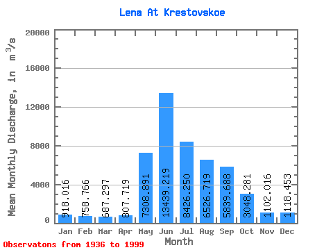
| Statistic | Jan | Feb | Mar | Apr | May | Jun | Jul | Aug | Sep | Oct | Nov | Dec | Annual |
|---|---|---|---|---|---|---|---|---|---|---|---|---|---|
| Mean | 918.02 | 758.77 | 687.30 | 807.72 | 7308.89 | 13439.22 | 8426.25 | 6526.72 | 5839.69 | 3048.28 | 1102.02 | 1118.45 | 4165.11 |
| Standard Deviation | 201.64 | 155.87 | 131.37 | 302.50 | 1626.49 | 3268.72 | 2548.76 | 2266.74 | 1957.10 | 842.19 | 306.64 | 258.34 | 613.68 |
| Min | 567.00 | 375.00 | 461.00 | 513.00 | 4009.00 | 6280.00 | 3700.00 | 3400.00 | 2940.00 | 1810.00 | 488.00 | 393.00 | 2892.67 |
| Max | 1420.00 | 1140.00 | 1030.00 | 2550.00 | 11100.00 | 20800.00 | 16000.00 | 13400.00 | 11700.00 | 5200.00 | 2140.00 | 1710.00 | 6050.50 |
| Coefficient of Variation | 0.22 | 0.20 | 0.19 | 0.38 | 0.22 | 0.24 | 0.30 | 0.35 | 0.34 | 0.28 | 0.28 | 0.23 | 0.15 |
 Return to R-Arctic Net Home Page