|
|
|||||||||||||||||
| Point ID: 6136 | Downloads | Plots | Site Data | Code: 3001 |
|
|
|||||||||||||||||
| Download | |
|---|---|
| Site Descriptor Information | Site Time Series Data |
| Link to all available data | |
| View: | Time Series | All |
| Units: | mm |
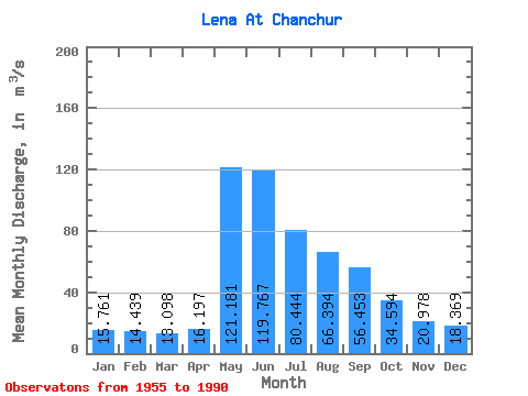
| Statistic | Jan | Feb | Mar | Apr | May | Jun | Jul | Aug | Sep | Oct | Nov | Dec | Annual |
|---|---|---|---|---|---|---|---|---|---|---|---|---|---|
| Mean | 15.76 | 14.44 | 13.10 | 16.20 | 121.18 | 119.77 | 80.44 | 66.39 | 56.45 | 34.59 | 20.98 | 18.37 | 48.14 |
| Standard Deviation | 3.38 | 2.87 | 2.28 | 6.77 | 27.03 | 37.34 | 52.86 | 33.36 | 25.05 | 13.84 | 4.73 | 3.40 | 9.22 |
| Min | 7.68 | 10.20 | 9.63 | 9.44 | 77.90 | 49.60 | 30.40 | 31.70 | 20.80 | 16.00 | 11.40 | 12.60 | 31.23 |
| Max | 21.40 | 21.70 | 18.30 | 43.70 | 190.00 | 178.00 | 325.00 | 152.00 | 128.00 | 91.80 | 30.00 | 25.30 | 77.18 |
| Coefficient of Variation | 0.21 | 0.20 | 0.17 | 0.42 | 0.22 | 0.31 | 0.66 | 0.50 | 0.44 | 0.40 | 0.23 | 0.18 | 0.19 |
 Return to R-Arctic Net Home Page