|
|
|||||||||||||||||
| Point ID: 613 | Downloads | Plots | Site Data | Code: 07AF002 |
|
|
|||||||||||||||||
| Download | |
|---|---|
| Site Descriptor Information | Site Time Series Data |
| Link to all available data | |
| View: | Time Series | All |
| Units: | mm |
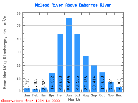
| Statistic | Jan | Feb | Mar | Apr | May | Jun | Jul | Aug | Sep | Oct | Nov | Dec | Annual |
|---|---|---|---|---|---|---|---|---|---|---|---|---|---|
| Mean | 2.72 | 2.48 | 3.33 | 14.33 | 43.63 | 55.69 | 43.56 | 27.13 | 20.41 | 14.68 | 7.40 | 4.00 | 19.94 |
| Standard Deviation | 0.92 | 0.64 | 1.82 | 6.96 | 17.85 | 33.31 | 27.14 | 21.54 | 14.45 | 9.42 | 3.46 | 1.50 | 6.13 |
| Min | 1.32 | 1.13 | 1.46 | 4.32 | 13.90 | 12.80 | 11.70 | 5.88 | 4.98 | 4.10 | 2.32 | 1.63 | 9.79 |
| Max | 5.88 | 4.04 | 11.70 | 31.20 | 93.10 | 203.00 | 127.00 | 105.00 | 66.10 | 40.10 | 13.90 | 7.61 | 35.69 |
| Coefficient of Variation | 0.34 | 0.26 | 0.55 | 0.48 | 0.41 | 0.60 | 0.62 | 0.79 | 0.71 | 0.64 | 0.47 | 0.37 | 0.31 |
 Return to R-Arctic Net Home Page