|
|
|||||||||||||||||
| Point ID: 6068 | Downloads | Plots | Site Data | Code: 7176 |
|
|
|||||||||||||||||
| Download | |
|---|---|
| Site Descriptor Information | Site Time Series Data |
| Link to all available data | |
| View: | Time Series | All |
| Units: | mm |
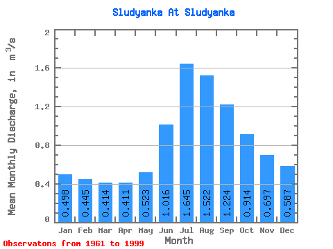
| Statistic | Jan | Feb | Mar | Apr | May | Jun | Jul | Aug | Sep | Oct | Nov | Dec | Annual |
|---|---|---|---|---|---|---|---|---|---|---|---|---|---|
| Mean | 0.50 | 0.45 | 0.41 | 0.41 | 0.52 | 1.02 | 1.65 | 1.52 | 1.22 | 0.91 | 0.70 | 0.59 | 0.82 |
| Standard Deviation | 0.21 | 0.18 | 0.17 | 0.17 | 0.21 | 0.64 | 1.20 | 0.85 | 0.68 | 0.45 | 0.29 | 0.23 | 0.28 |
| Min | 0.18 | 0.18 | 0.18 | 0.15 | 0.18 | 0.21 | 0.11 | 0.24 | 0.43 | 0.35 | 0.28 | 0.25 | 0.34 |
| Max | 1.04 | 0.86 | 0.80 | 0.80 | 1.01 | 3.80 | 6.51 | 4.45 | 3.15 | 1.88 | 1.24 | 1.12 | 1.37 |
| Coefficient of Variation | 0.42 | 0.41 | 0.42 | 0.41 | 0.41 | 0.63 | 0.73 | 0.56 | 0.55 | 0.49 | 0.42 | 0.40 | 0.34 |
 Return to R-Arctic Net Home Page