|
|
|||||||||||||||||
| Point ID: 6062 | Downloads | Plots | Site Data | Code: 7156 |
|
|
|||||||||||||||||
| Download | |
|---|---|
| Site Descriptor Information | Site Time Series Data |
| Link to all available data | |
| View: | Time Series | All |
| Units: | mm |
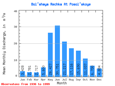
| Statistic | Jan | Feb | Mar | Apr | May | Jun | Jul | Aug | Sep | Oct | Nov | Dec | Annual |
|---|---|---|---|---|---|---|---|---|---|---|---|---|---|
| Mean | 3.43 | 2.78 | 2.72 | 5.60 | 26.43 | 30.75 | 21.22 | 17.12 | 15.69 | 11.04 | 6.73 | 4.88 | 12.37 |
| Standard Deviation | 0.88 | 0.79 | 0.91 | 2.53 | 7.70 | 13.93 | 12.70 | 8.69 | 6.84 | 3.66 | 1.83 | 1.64 | 2.89 |
| Min | 1.59 | 0.93 | 0.98 | 2.32 | 13.50 | 0.88 | 6.66 | 6.74 | 7.07 | 5.70 | 3.35 | 0.27 | 7.16 |
| Max | 5.86 | 4.40 | 5.32 | 14.70 | 47.10 | 72.90 | 62.90 | 51.10 | 44.70 | 24.20 | 12.30 | 11.90 | 20.45 |
| Coefficient of Variation | 0.26 | 0.29 | 0.34 | 0.45 | 0.29 | 0.45 | 0.60 | 0.51 | 0.44 | 0.33 | 0.27 | 0.34 | 0.23 |
 Return to R-Arctic Net Home Page