|
|
|||||||||||||||||
| Point ID: 6056 | Downloads | Plots | Site Data | Code: 7116 |
|
|
|||||||||||||||||
| Download | |
|---|---|
| Site Descriptor Information | Site Time Series Data |
| Link to all available data | |
| View: | Time Series | All |
| Units: | mm |
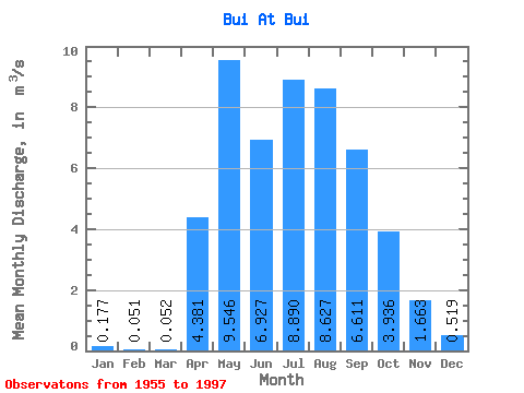
| Statistic | Jan | Feb | Mar | Apr | May | Jun | Jul | Aug | Sep | Oct | Nov | Dec | Annual |
|---|---|---|---|---|---|---|---|---|---|---|---|---|---|
| Mean | 0.18 | 0.05 | 0.05 | 4.38 | 9.55 | 6.93 | 8.89 | 8.63 | 6.61 | 3.94 | 1.66 | 0.52 | 4.31 |
| Standard Deviation | 0.24 | 0.09 | 0.11 | 2.37 | 4.93 | 5.02 | 6.71 | 7.39 | 4.18 | 2.22 | 1.10 | 0.44 | 1.82 |
| Min | 0.00 | 0.00 | 0.00 | 0.74 | 2.95 | 0.51 | 1.46 | 1.32 | 1.27 | 1.03 | 0.30 | 0.01 | 1.28 |
| Max | 1.16 | 0.36 | 0.51 | 11.60 | 19.40 | 23.80 | 28.90 | 40.40 | 22.10 | 12.40 | 4.83 | 1.73 | 9.13 |
| Coefficient of Variation | 1.35 | 1.84 | 2.07 | 0.54 | 0.52 | 0.72 | 0.75 | 0.86 | 0.63 | 0.56 | 0.66 | 0.85 | 0.42 |
 Return to R-Arctic Net Home Page