|
|
|||||||||||||||||
| Point ID: 6055 | Downloads | Plots | Site Data | Code: 7114 |
|
|
|||||||||||||||||
| Download | |
|---|---|
| Site Descriptor Information | Site Time Series Data |
| Link to all available data | |
| View: | Time Series | All |
| Units: | mm |
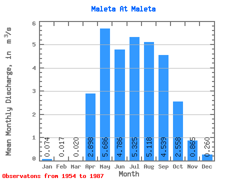
| Statistic | Jan | Feb | Mar | Apr | May | Jun | Jul | Aug | Sep | Oct | Nov | Dec | Annual |
|---|---|---|---|---|---|---|---|---|---|---|---|---|---|
| Mean | 0.07 | 0.02 | 0.02 | 2.90 | 5.69 | 4.79 | 5.33 | 5.12 | 4.54 | 2.56 | 0.86 | 0.26 | 2.68 |
| Standard Deviation | 0.15 | 0.06 | 0.08 | 1.69 | 2.35 | 3.81 | 4.53 | 3.86 | 3.01 | 1.33 | 0.63 | 0.35 | 1.28 |
| Min | 0.00 | 0.00 | 0.00 | 0.81 | 2.00 | 1.26 | 1.29 | 1.08 | 1.00 | 0.71 | 0.12 | 0.00 | 0.90 |
| Max | 0.68 | 0.25 | 0.45 | 8.71 | 12.00 | 19.50 | 20.40 | 17.10 | 13.00 | 5.99 | 2.35 | 1.08 | 5.78 |
| Coefficient of Variation | 2.02 | 3.28 | 3.98 | 0.58 | 0.41 | 0.80 | 0.85 | 0.75 | 0.66 | 0.52 | 0.73 | 1.34 | 0.48 |
 Return to R-Arctic Net Home Page