|
|
|||||||||||||||||
| Point ID: 6048 | Downloads | Plots | Site Data | Code: 7034 |
|
|
|||||||||||||||||
| Download | |
|---|---|
| Site Descriptor Information | Site Time Series Data |
| Link to all available data | |
| View: | Time Series | All |
| Units: | mm |
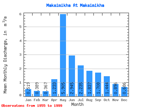
| Statistic | Jan | Feb | Mar | Apr | May | Jun | Jul | Aug | Sep | Oct | Nov | Dec | Annual |
|---|---|---|---|---|---|---|---|---|---|---|---|---|---|
| Mean | 0.52 | 0.39 | 0.37 | 1.23 | 5.91 | 2.94 | 2.23 | 1.84 | 1.71 | 1.44 | 0.90 | 0.69 | 1.68 |
| Standard Deviation | 0.17 | 0.17 | 0.20 | 0.75 | 2.27 | 1.57 | 1.75 | 1.19 | 1.04 | 0.64 | 0.33 | 0.22 | 0.52 |
| Min | 0.14 | 0.09 | 0.09 | 0.25 | 1.72 | 0.82 | 0.62 | 0.54 | 0.53 | 0.59 | 0.35 | 0.26 | 0.80 |
| Max | 0.96 | 0.91 | 0.93 | 3.57 | 11.70 | 9.66 | 11.20 | 5.88 | 5.41 | 3.02 | 1.65 | 1.27 | 2.88 |
| Coefficient of Variation | 0.33 | 0.42 | 0.55 | 0.61 | 0.38 | 0.53 | 0.78 | 0.65 | 0.61 | 0.44 | 0.36 | 0.32 | 0.31 |
 Return to R-Arctic Net Home Page