|
|
|||||||||||||||||
| Point ID: 5944 | Downloads | Plots | Site Data | Code: 1597 |
|
|
|||||||||||||||||
| Download | |
|---|---|
| Site Descriptor Information | Site Time Series Data |
| Link to all available data | |
| View: | Time Series | All |
| Units: | mm |
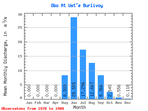
| Statistic | Jan | Feb | Mar | Apr | May | Jun | Jul | Aug | Sep | Oct | Nov | Dec | Annual |
|---|---|---|---|---|---|---|---|---|---|---|---|---|---|
| Mean | 0.00 | 0.00 | 0.00 | 0.00 | 8.30 | 28.55 | 17.30 | 12.67 | 8.37 | 2.54 | 0.56 | 0.12 | 6.43 |
| Standard Deviation | 0.00 | 0.00 | 0.00 | 0.00 | 4.68 | 17.62 | 8.74 | 4.59 | 4.97 | 1.13 | 0.56 | 0.15 | 1.69 |
| Min | 0.00 | 0.00 | 0.00 | 0.00 | 1.88 | 11.60 | 7.29 | 7.11 | 2.90 | 1.07 | 0.00 | 0.00 | 4.75 |
| Max | 0.00 | 0.00 | 0.00 | 0.00 | 13.60 | 71.70 | 33.60 | 22.80 | 19.80 | 5.45 | 1.47 | 0.42 | 9.94 |
| Coefficient of Variation | 0.56 | 0.62 | 0.51 | 0.36 | 0.59 | 0.44 | 1.00 | 1.31 | 0.26 |
 Return to R-Arctic Net Home Page