|
|
|||||||||||||||||
| Point ID: 5911 | Downloads | Plots | Site Data | Code: 1421 |
|
|
|||||||||||||||||
| Download | |
|---|---|
| Site Descriptor Information | Site Time Series Data |
| Link to all available data | |
| View: | Time Series | All |
| Units: | mm |
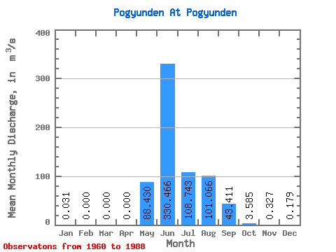
| Statistic | Jan | Feb | Mar | Apr | May | Jun | Jul | Aug | Sep | Oct | Nov | Dec | Annual |
|---|---|---|---|---|---|---|---|---|---|---|---|---|---|
| Mean | 0.03 | 0.00 | 0.00 | 0.00 | 88.43 | 330.47 | 108.74 | 101.07 | 43.41 | 3.58 | 0.33 | 0.18 | 74.70 |
| Standard Deviation | 0.06 | 0.00 | 0.00 | 0.00 | 101.98 | 168.96 | 70.58 | 81.98 | 29.32 | 2.43 | 0.31 | 0.42 | 14.45 |
| Min | 0.00 | 0.00 | 0.00 | 0.00 | 0.68 | 71.50 | 31.50 | 16.30 | 7.72 | 0.99 | 0.01 | 0.00 | 59.05 |
| Max | 0.12 | 0.00 | 0.00 | 0.00 | 472.00 | 809.00 | 316.00 | 381.00 | 118.00 | 13.70 | 1.23 | 1.12 | 87.53 |
| Coefficient of Variation | 1.88 | 1.15 | 0.51 | 0.65 | 0.81 | 0.68 | 0.68 | 0.95 | 2.33 | 0.19 |
 Return to R-Arctic Net Home Page