|
|
|||||||||||||||||
| Point ID: 5910 | Downloads | Plots | Site Data | Code: 1399 |
|
|
|||||||||||||||||
| Download | |
|---|---|
| Site Descriptor Information | Site Time Series Data |
| Link to all available data | |
| View: | Time Series | All |
| Units: | mm |
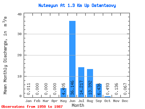
| Statistic | Jan | Feb | Mar | Apr | May | Jun | Jul | Aug | Sep | Oct | Nov | Dec | Annual |
|---|---|---|---|---|---|---|---|---|---|---|---|---|---|
| Mean | 0.01 | 0.00 | 0.00 | 0.00 | 4.41 | 36.15 | 14.22 | 13.39 | 6.44 | 0.49 | 0.14 | 0.07 | 7.38 |
| Standard Deviation | 0.01 | 0.00 | 0.00 | 0.00 | 4.20 | 11.11 | 7.83 | 6.55 | 5.10 | 0.29 | 0.09 | 0.04 | 0.61 |
| Min | 0.00 | 0.00 | 0.00 | 0.00 | 0.00 | 14.10 | 4.88 | 4.11 | 0.66 | 0.06 | 0.03 | 0.00 | 6.94 |
| Max | 0.02 | 0.00 | 0.00 | 0.00 | 15.20 | 68.10 | 40.10 | 27.50 | 24.40 | 1.06 | 0.34 | 0.12 | 7.81 |
| Coefficient of Variation | 0.57 | 0.95 | 0.31 | 0.55 | 0.49 | 0.79 | 0.59 | 0.65 | 0.59 | 0.08 |
 Return to R-Arctic Net Home Page