|
|
|||||||||||||||||
| Point ID: 5903 | Downloads | Plots | Site Data | Code: 1368 |
|
|
|||||||||||||||||
| Download | |
|---|---|
| Site Descriptor Information | Site Time Series Data |
| Link to all available data | |
| View: | Time Series | All |
| Units: | mm |
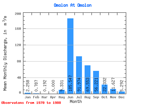
| Statistic | Jan | Feb | Mar | Apr | May | Jun | Jul | Aug | Sep | Oct | Nov | Dec | Annual |
|---|---|---|---|---|---|---|---|---|---|---|---|---|---|
| Mean | 2.26 | 0.79 | 0.19 | 0.00 | 9.33 | 185.55 | 91.97 | 69.55 | 56.22 | 22.33 | 11.63 | 5.29 | 40.64 |
| Standard Deviation | 1.51 | 0.69 | 0.15 | 0.00 | 12.44 | 49.77 | 39.33 | 25.06 | 25.43 | 4.33 | 3.17 | 2.75 | 1.92 |
| Min | 0.06 | 0.01 | 0.01 | 0.00 | 0.11 | 88.40 | 46.90 | 34.20 | 24.30 | 12.90 | 3.65 | 0.20 | 38.74 |
| Max | 4.96 | 2.09 | 0.44 | 0.00 | 37.20 | 286.00 | 181.00 | 126.00 | 124.00 | 32.10 | 15.90 | 9.50 | 42.58 |
| Coefficient of Variation | 0.67 | 0.88 | 0.78 | 1.33 | 0.27 | 0.43 | 0.36 | 0.45 | 0.19 | 0.27 | 0.52 | 0.05 |
 Return to R-Arctic Net Home Page