|
|
|||||||||||||||||
| Point ID: 5896 | Downloads | Plots | Site Data | Code: 1314 |
|
|
|||||||||||||||||
| Download | |
|---|---|
| Site Descriptor Information | Site Time Series Data |
| Link to all available data | |
| View: | Time Series | All |
| Units: | mm |
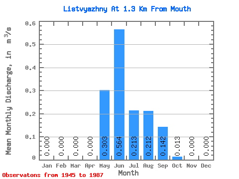
| Statistic | Jan | Feb | Mar | Apr | May | Jun | Jul | Aug | Sep | Oct | Nov | Dec | Annual |
|---|---|---|---|---|---|---|---|---|---|---|---|---|---|
| Mean | 0.00 | 0.00 | 0.00 | 0.00 | 0.30 | 0.56 | 0.21 | 0.21 | 0.14 | 0.01 | 0.00 | 0.00 | 0.12 |
| Standard Deviation | 0.00 | 0.00 | 0.00 | 0.00 | 0.16 | 0.38 | 0.18 | 0.14 | 0.11 | 0.01 | 0.00 | 0.00 | 0.01 |
| Min | 0.00 | 0.00 | 0.00 | 0.00 | 0.00 | 0.15 | 0.04 | 0.07 | 0.04 | 0.00 | 0.00 | 0.00 | 0.12 |
| Max | 0.00 | 0.00 | 0.00 | 0.00 | 0.69 | 1.49 | 0.86 | 0.70 | 0.58 | 0.04 | 0.00 | 0.00 | 0.13 |
| Coefficient of Variation | 0.54 | 0.67 | 0.84 | 0.66 | 0.75 | 0.67 | 0.05 |
 Return to R-Arctic Net Home Page