|
|
|||||||||||||||||
| Point ID: 589 | Downloads | Plots | Site Data | Code: 07AA010 |
|
|
|||||||||||||||||
| Download | |
|---|---|
| Site Descriptor Information | Site Time Series Data |
| Link to all available data | |
| View: | Time Series | All |
| Units: | mm |
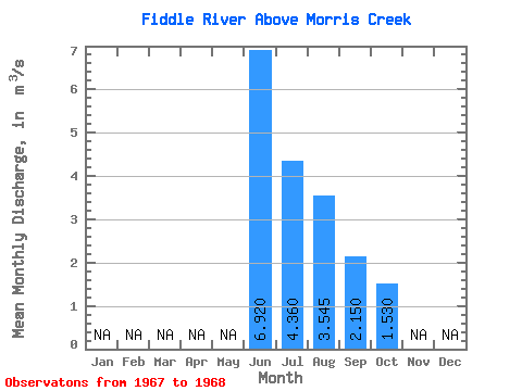
| Statistic | Jan | Feb | Mar | Apr | May | Jun | Jul | Aug | Sep | Oct | Nov | Dec | Annual |
|---|---|---|---|---|---|---|---|---|---|---|---|---|---|
| Mean | 6.92 | 4.36 | 3.54 | 2.15 | 1.53 | ||||||||
| Standard Deviation | 2.03 | 0.95 | 0.33 | ||||||||||
| Min | 6.92 | 4.36 | 2.11 | 1.48 | 1.30 | ||||||||
| Max | 6.92 | 4.36 | 4.98 | 2.82 | 1.76 | ||||||||
| Coefficient of Variation | 0.57 | 0.44 | 0.21 |
 Return to R-Arctic Net Home Page