|
|
|||||||||||||||||
| Point ID: 5885 | Downloads | Plots | Site Data | Code: 1240 |
|
|
|||||||||||||||||
| Download | |
|---|---|
| Site Descriptor Information | Site Time Series Data |
| Link to all available data | |
| View: | Time Series | All |
| Units: | mm |
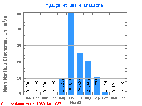
| Statistic | Jan | Feb | Mar | Apr | May | Jun | Jul | Aug | Sep | Oct | Nov | Dec | Annual |
|---|---|---|---|---|---|---|---|---|---|---|---|---|---|
| Mean | 0.00 | 0.00 | 0.00 | 0.00 | 10.22 | 49.82 | 25.53 | 20.41 | 10.78 | 1.44 | 0.12 | 0.00 | 10.61 |
| Standard Deviation | 0.00 | 0.00 | 0.00 | 0.00 | 6.88 | 19.98 | 13.39 | 8.51 | 5.60 | 0.58 | 0.12 | 0.00 | 0.01 |
| Min | 0.00 | 0.00 | 0.00 | 0.00 | 0.70 | 22.90 | 10.80 | 8.73 | 3.03 | 0.52 | 0.00 | 0.00 | 10.61 |
| Max | 0.00 | 0.00 | 0.00 | 0.00 | 22.70 | 96.50 | 58.90 | 39.40 | 20.80 | 2.60 | 0.41 | 0.01 | 10.62 |
| Coefficient of Variation | 0.67 | 0.40 | 0.52 | 0.42 | 0.52 | 0.40 | 0.98 | 1.25 | 0.00 |
 Return to R-Arctic Net Home Page