|
|
|||||||||||||||||
| Point ID: 5873 | Downloads | Plots | Site Data | Code: 1147 |
|
|
|||||||||||||||||
| Download | |
|---|---|
| Site Descriptor Information | Site Time Series Data |
| Link to all available data | |
| View: | Time Series | All |
| Units: | mm |
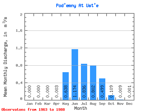
| Statistic | Jan | Feb | Mar | Apr | May | Jun | Jul | Aug | Sep | Oct | Nov | Dec | Annual |
|---|---|---|---|---|---|---|---|---|---|---|---|---|---|
| Mean | 0.00 | 0.00 | 0.00 | 0.00 | 0.64 | 1.17 | 0.84 | 0.80 | 0.50 | 0.11 | 0.01 | 0.00 | 0.35 |
| Standard Deviation | 0.00 | 0.00 | 0.00 | 0.00 | 0.38 | 0.57 | 0.39 | 0.40 | 0.34 | 0.07 | 0.01 | 0.00 | 0.11 |
| Min | 0.00 | 0.00 | 0.00 | 0.00 | 0.19 | 0.49 | 0.26 | 0.27 | 0.14 | 0.03 | 0.00 | 0.00 | 0.27 |
| Max | 0.00 | 0.00 | 0.00 | 0.01 | 1.88 | 2.66 | 1.90 | 1.80 | 1.26 | 0.35 | 0.03 | 0.00 | 0.48 |
| Coefficient of Variation | 1.02 | 0.60 | 0.49 | 0.47 | 0.50 | 0.68 | 0.65 | 0.91 | 2.00 | 0.31 |
 Return to R-Arctic Net Home Page