|
|
|||||||||||||||||
| Point ID: 5869 | Downloads | Plots | Site Data | Code: 1127 |
|
|
|||||||||||||||||
| Download | |
|---|---|
| Site Descriptor Information | Site Time Series Data |
| Link to all available data | |
| View: | Time Series | All |
| Units: | mm |
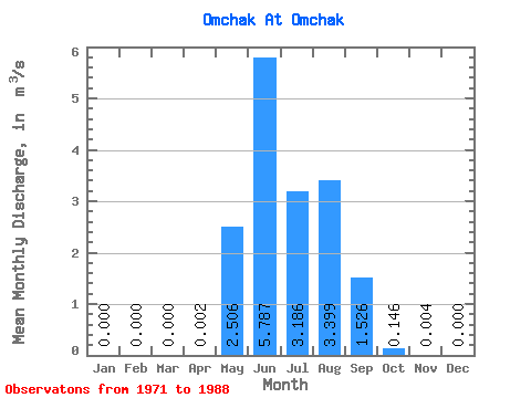
| Statistic | Jan | Feb | Mar | Apr | May | Jun | Jul | Aug | Sep | Oct | Nov | Dec | Annual |
|---|---|---|---|---|---|---|---|---|---|---|---|---|---|
| Mean | 0.00 | 0.00 | 0.00 | 0.00 | 2.51 | 5.79 | 3.19 | 3.40 | 1.53 | 0.15 | 0.00 | 0.00 | 1.56 |
| Standard Deviation | 0.00 | 0.00 | 0.00 | 0.00 | 2.20 | 4.21 | 1.22 | 2.01 | 1.09 | 0.08 | 0.01 | 0.00 | 0.53 |
| Min | 0.00 | 0.00 | 0.00 | 0.00 | 0.10 | 1.47 | 1.22 | 0.70 | 0.25 | 0.05 | 0.00 | 0.00 | 0.98 |
| Max | 0.00 | 0.00 | 0.00 | 0.01 | 8.83 | 17.00 | 5.59 | 7.39 | 4.22 | 0.33 | 0.02 | 0.00 | 2.03 |
| Coefficient of Variation | 1.54 | 0.88 | 0.73 | 0.38 | 0.59 | 0.71 | 0.58 | 1.52 | 0.34 |
 Return to R-Arctic Net Home Page