|
|
|||||||||||||||||
| Point ID: 5836 | Downloads | Plots | Site Data | Other Close Sites | Code: 09FC001 |
|
|
|||||||||||||||||
| Download | |
|---|---|
| Site Descriptor Information | Site Time Series Data |
| Link to all available data | |
| View: | Time Series | All |
| Units: | mm |
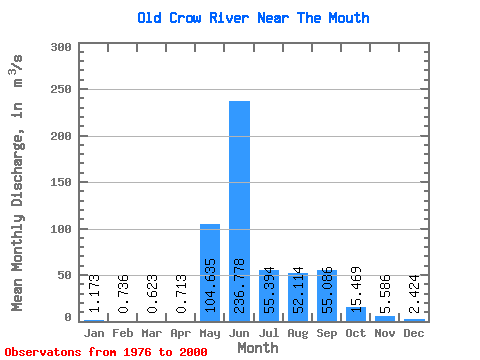
| Statistic | Jan | Feb | Mar | Apr | May | Jun | Jul | Aug | Sep | Oct | Nov | Dec | Annual |
|---|---|---|---|---|---|---|---|---|---|---|---|---|---|
| Mean | 1.17 | 0.74 | 0.62 | 0.71 | 104.64 | 236.78 | 55.39 | 52.11 | 55.09 | 15.47 | 5.59 | 2.42 | 45.26 |
| Standard Deviation | 0.82 | 0.54 | 0.40 | 0.35 | 84.46 | 135.60 | 28.26 | 47.17 | 44.61 | 12.14 | 5.13 | 1.90 | 20.07 |
| Min | 0.10 | 0.02 | 0.02 | 0.00 | 1.26 | 53.70 | 11.90 | 8.27 | 4.67 | 1.73 | 0.34 | 0.12 | 15.03 |
| Max | 3.95 | 2.19 | 1.32 | 1.21 | 282.00 | 634.00 | 96.30 | 165.00 | 167.00 | 52.10 | 23.30 | 8.31 | 74.88 |
| Coefficient of Variation | 0.70 | 0.73 | 0.64 | 0.49 | 0.81 | 0.57 | 0.51 | 0.91 | 0.81 | 0.79 | 0.92 | 0.79 | 0.44 |
| Other Close Sites | ||||||
|---|---|---|---|---|---|---|
| PointID | Latitude | Longitude | Drainage Area | Source | Name | |
| 5837 | "PORCUPINE RIVER AT OLD CROW" | 67.56 | 1895978 | Hydat | ||
 Return to R-Arctic Net Home Page