|
|
|||||||||||||||||
| Point ID: 583 | Downloads | Plots | Site Data | Code: 07AA002 |
|
|
|||||||||||||||||
| Download | |
|---|---|
| Site Descriptor Information | Site Time Series Data |
| Link to all available data | |
| View: | Time Series | All |
| Units: | mm |
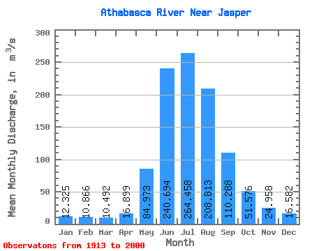
| Statistic | Jan | Feb | Mar | Apr | May | Jun | Jul | Aug | Sep | Oct | Nov | Dec | Annual |
|---|---|---|---|---|---|---|---|---|---|---|---|---|---|
| Mean | 12.32 | 10.87 | 10.49 | 16.90 | 84.97 | 240.69 | 264.46 | 208.81 | 110.29 | 51.58 | 24.96 | 16.58 | 87.29 |
| Standard Deviation | 2.46 | 1.60 | 1.60 | 6.54 | 34.74 | 47.60 | 45.98 | 38.22 | 23.39 | 14.60 | 6.04 | 4.16 | 8.91 |
| Min | 6.84 | 6.47 | 6.68 | 9.17 | 28.20 | 154.00 | 173.00 | 152.00 | 62.30 | 31.70 | 12.80 | 8.74 | 71.29 |
| Max | 20.90 | 14.80 | 13.60 | 39.70 | 174.00 | 374.00 | 390.00 | 341.00 | 195.00 | 120.00 | 40.00 | 30.70 | 112.78 |
| Coefficient of Variation | 0.20 | 0.15 | 0.15 | 0.39 | 0.41 | 0.20 | 0.17 | 0.18 | 0.21 | 0.28 | 0.24 | 0.25 | 0.10 |
 Return to R-Arctic Net Home Page