|
|
|||||||||||||||||
| Point ID: 5817 | Downloads | Plots | Site Data | Code: 09DA001 |
|
|
|||||||||||||||||
| Download | |
|---|---|
| Site Descriptor Information | Site Time Series Data |
| Link to all available data | |
| View: | Time Series | All |
| Units: | mm |
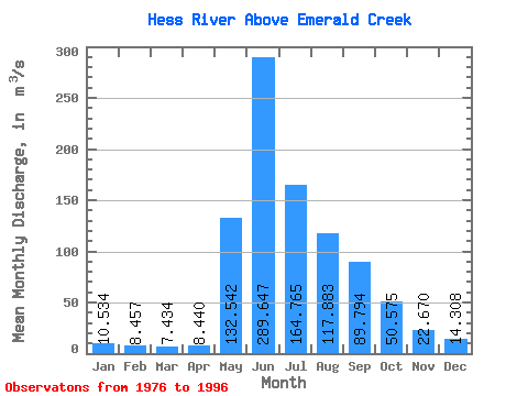
| Statistic | Jan | Feb | Mar | Apr | May | Jun | Jul | Aug | Sep | Oct | Nov | Dec | Annual |
|---|---|---|---|---|---|---|---|---|---|---|---|---|---|
| Mean | 10.53 | 8.46 | 7.43 | 8.44 | 132.54 | 289.65 | 164.76 | 117.88 | 89.79 | 50.58 | 22.67 | 14.31 | 77.56 |
| Standard Deviation | 2.47 | 2.49 | 2.68 | 3.38 | 59.98 | 80.16 | 39.21 | 27.11 | 36.28 | 12.98 | 5.25 | 2.98 | 12.05 |
| Min | 7.57 | 5.18 | 3.78 | 3.69 | 11.10 | 158.00 | 109.00 | 65.10 | 49.20 | 32.40 | 15.50 | 9.90 | 56.96 |
| Max | 14.70 | 14.20 | 13.50 | 17.00 | 242.00 | 474.00 | 247.00 | 172.00 | 204.00 | 74.20 | 32.40 | 18.90 | 97.52 |
| Coefficient of Variation | 0.23 | 0.29 | 0.36 | 0.40 | 0.45 | 0.28 | 0.24 | 0.23 | 0.40 | 0.26 | 0.23 | 0.21 | 0.15 |
 Return to R-Arctic Net Home Page