|
|
|||||||||||||||||
| Point ID: 5804 | Downloads | Plots | Site Data | Code: 09BB001 |
|
|
|||||||||||||||||
| Download | |
|---|---|
| Site Descriptor Information | Site Time Series Data |
| Link to all available data | |
| View: | Time Series | All |
| Units: | mm |
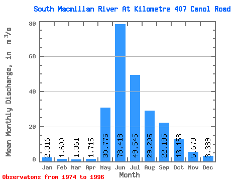
| Statistic | Jan | Feb | Mar | Apr | May | Jun | Jul | Aug | Sep | Oct | Nov | Dec | Annual |
|---|---|---|---|---|---|---|---|---|---|---|---|---|---|
| Mean | 2.32 | 1.60 | 1.36 | 1.71 | 30.77 | 78.42 | 49.55 | 29.20 | 22.20 | 13.16 | 5.68 | 3.39 | 19.95 |
| Standard Deviation | 0.58 | 0.47 | 0.51 | 0.84 | 14.90 | 16.04 | 12.73 | 7.16 | 10.89 | 3.82 | 1.56 | 0.85 | 2.62 |
| Min | 1.35 | 0.75 | 0.43 | 0.52 | 3.85 | 46.70 | 30.20 | 17.80 | 11.00 | 6.44 | 3.80 | 2.12 | 14.60 |
| Max | 3.35 | 2.40 | 2.25 | 3.60 | 62.40 | 109.00 | 72.90 | 42.70 | 58.90 | 19.70 | 10.20 | 5.06 | 24.62 |
| Coefficient of Variation | 0.25 | 0.29 | 0.37 | 0.49 | 0.48 | 0.20 | 0.26 | 0.24 | 0.49 | 0.29 | 0.28 | 0.25 | 0.13 |
 Return to R-Arctic Net Home Page