|
|
|||||||||||||||||
| Point ID: 580 | Downloads | Plots | Site Data | Code: 06AF001 |
|
|
|||||||||||||||||
| Download | |
|---|---|
| Site Descriptor Information | Site Time Series Data |
| Link to all available data | |
| View: | Time Series | All |
| Units: | mm |
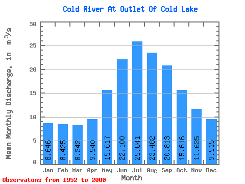
| Statistic | Jan | Feb | Mar | Apr | May | Jun | Jul | Aug | Sep | Oct | Nov | Dec | Annual |
|---|---|---|---|---|---|---|---|---|---|---|---|---|---|
| Mean | 8.65 | 8.43 | 8.24 | 9.54 | 15.62 | 22.10 | 25.84 | 23.48 | 20.81 | 15.62 | 11.63 | 9.52 | 15.30 |
| Standard Deviation | 9.07 | 8.45 | 7.11 | 7.38 | 13.12 | 19.52 | 25.18 | 22.39 | 20.76 | 15.97 | 11.71 | 9.96 | 12.71 |
| Min | 0.00 | 0.00 | 0.00 | 0.02 | 0.16 | 0.11 | 0.36 | 0.38 | 1.50 | 1.14 | 0.79 | 0.37 | 0.40 |
| Max | 26.40 | 23.50 | 20.60 | 24.70 | 45.70 | 67.10 | 101.00 | 75.80 | 79.70 | 56.30 | 36.60 | 30.40 | 44.52 |
| Coefficient of Variation | 1.05 | 1.00 | 0.86 | 0.77 | 0.84 | 0.88 | 0.97 | 0.95 | 1.00 | 1.02 | 1.01 | 1.05 | 0.83 |
 Return to R-Arctic Net Home Page