|
|
|||||||||||||||||
| Point ID: 5792 | Downloads | Plots | Site Data | Code: 09AC007 |
|
|
|||||||||||||||||
| Download | |
|---|---|
| Site Descriptor Information | Site Time Series Data |
| Link to all available data | |
| View: | Time Series | All |
| Units: | mm |
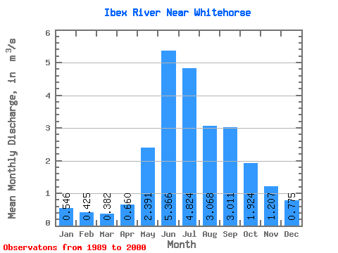
| Statistic | Jan | Feb | Mar | Apr | May | Jun | Jul | Aug | Sep | Oct | Nov | Dec | Annual |
|---|---|---|---|---|---|---|---|---|---|---|---|---|---|
| Mean | 0.55 | 0.42 | 0.38 | 0.66 | 2.39 | 5.37 | 4.82 | 3.07 | 3.01 | 1.92 | 1.21 | 0.78 | 2.07 |
| Standard Deviation | 0.17 | 0.14 | 0.12 | 0.25 | 1.08 | 2.47 | 1.60 | 1.40 | 1.66 | 0.71 | 0.42 | 0.18 | 0.45 |
| Min | 0.25 | 0.19 | 0.21 | 0.30 | 0.76 | 2.60 | 2.97 | 1.69 | 1.36 | 0.98 | 0.58 | 0.43 | 1.35 |
| Max | 0.84 | 0.68 | 0.56 | 1.07 | 4.15 | 10.20 | 7.57 | 5.93 | 6.88 | 3.07 | 2.16 | 1.00 | 2.62 |
| Coefficient of Variation | 0.32 | 0.33 | 0.32 | 0.38 | 0.45 | 0.46 | 0.33 | 0.46 | 0.55 | 0.37 | 0.35 | 0.23 | 0.22 |
 Return to R-Arctic Net Home Page