|
|
|||||||||||||||||
| Point ID: 578 | Downloads | Plots | Site Data | Code: 06AD006 |
|
|
|||||||||||||||||
| Download | |
|---|---|
| Site Descriptor Information | Site Time Series Data |
| Link to all available data | |
| View: | Time Series | All |
| Units: | mm |
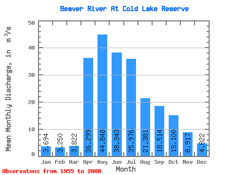
| Statistic | Jan | Feb | Mar | Apr | May | Jun | Jul | Aug | Sep | Oct | Nov | Dec | Annual |
|---|---|---|---|---|---|---|---|---|---|---|---|---|---|
| Mean | 3.69 | 3.25 | 3.82 | 36.30 | 44.85 | 38.34 | 35.98 | 21.38 | 18.51 | 15.10 | 8.92 | 4.82 | 19.61 |
| Standard Deviation | 2.77 | 2.26 | 2.31 | 31.99 | 44.59 | 49.93 | 42.46 | 21.96 | 17.75 | 13.42 | 8.03 | 4.21 | 14.92 |
| Min | 0.51 | 0.44 | 0.70 | 5.09 | 3.33 | 2.69 | 1.87 | 1.04 | 1.05 | 0.99 | 0.73 | 0.76 | 2.02 |
| Max | 11.80 | 9.80 | 9.69 | 154.00 | 248.00 | 284.00 | 164.00 | 97.00 | 77.80 | 53.70 | 34.10 | 17.80 | 60.69 |
| Coefficient of Variation | 0.75 | 0.69 | 0.60 | 0.88 | 0.99 | 1.30 | 1.18 | 1.03 | 0.96 | 0.89 | 0.90 | 0.87 | 0.76 |
 Return to R-Arctic Net Home Page