|
|
|||||||||||||||||
| Point ID: 5612 | Downloads | Plots | Site Data | Code: 07LD002 |
|
|
|||||||||||||||||
| Download | |
|---|---|
| Site Descriptor Information | Site Time Series Data |
| Link to all available data | |
| View: | Time Series | All |
| Units: | mm |
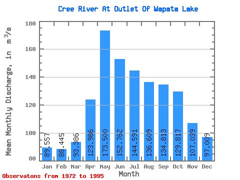
| Statistic | Jan | Feb | Mar | Apr | May | Jun | Jul | Aug | Sep | Oct | Nov | Dec | Annual |
|---|---|---|---|---|---|---|---|---|---|---|---|---|---|
| Mean | 89.56 | 88.44 | 93.39 | 123.99 | 173.50 | 152.76 | 144.59 | 136.61 | 134.81 | 129.82 | 107.04 | 97.01 | 123.36 |
| Standard Deviation | 14.13 | 15.14 | 16.64 | 20.39 | 25.96 | 23.32 | 19.18 | 17.86 | 21.67 | 21.26 | 16.95 | 14.54 | 13.14 |
| Min | 60.20 | 48.00 | 49.30 | 61.90 | 137.00 | 111.00 | 115.00 | 106.00 | 94.70 | 88.80 | 79.00 | 67.50 | 101.58 |
| Max | 115.00 | 116.00 | 126.00 | 157.00 | 223.00 | 199.00 | 194.00 | 181.00 | 180.00 | 171.00 | 144.00 | 115.00 | 153.83 |
| Coefficient of Variation | 0.16 | 0.17 | 0.18 | 0.16 | 0.15 | 0.15 | 0.13 | 0.13 | 0.16 | 0.16 | 0.16 | 0.15 | 0.11 |
 Return to R-Arctic Net Home Page