|
|
|||||||||||||||||
| Point ID: 5610 | Downloads | Plots | Site Data | Code: 07LC002 |
|
|
|||||||||||||||||
| Download | |
|---|---|
| Site Descriptor Information | Site Time Series Data |
| Link to all available data | |
| View: | Time Series | All |
| Units: | mm |
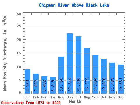
| Statistic | Jan | Feb | Mar | Apr | May | Jun | Jul | Aug | Sep | Oct | Nov | Dec | Annual |
|---|---|---|---|---|---|---|---|---|---|---|---|---|---|
| Mean | 8.93 | 7.45 | 6.48 | 6.22 | 13.76 | 22.34 | 21.13 | 16.78 | 14.30 | 12.87 | 11.49 | 10.68 | 12.87 |
| Standard Deviation | 3.17 | 2.27 | 1.68 | 1.52 | 6.38 | 8.04 | 7.37 | 6.07 | 6.23 | 6.01 | 5.67 | 4.36 | 3.58 |
| Min | 4.76 | 4.37 | 4.13 | 4.07 | 5.65 | 10.60 | 12.20 | 9.19 | 6.28 | 5.75 | 4.72 | 5.03 | 6.64 |
| Max | 15.60 | 12.70 | 10.40 | 9.12 | 27.50 | 34.10 | 41.10 | 35.10 | 32.20 | 28.00 | 25.30 | 19.30 | 20.92 |
| Coefficient of Variation | 0.35 | 0.30 | 0.26 | 0.24 | 0.46 | 0.36 | 0.35 | 0.36 | 0.44 | 0.47 | 0.49 | 0.41 | 0.28 |
 Return to R-Arctic Net Home Page