|
|
|||||||||||||||||
| Point ID: 5604 | Downloads | Plots | Site Data | Code: 06EA007 |
|
|
|||||||||||||||||
| Download | |
|---|---|
| Site Descriptor Information | Site Time Series Data |
| Link to all available data | |
| View: | Time Series | All |
| Units: | mm |
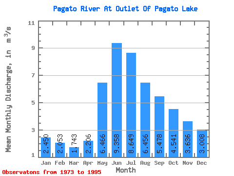
| Statistic | Jan | Feb | Mar | Apr | May | Jun | Jul | Aug | Sep | Oct | Nov | Dec | Annual |
|---|---|---|---|---|---|---|---|---|---|---|---|---|---|
| Mean | 2.45 | 2.05 | 1.74 | 2.21 | 6.47 | 9.36 | 8.65 | 6.46 | 5.48 | 4.54 | 3.64 | 3.01 | 4.74 |
| Standard Deviation | 1.23 | 0.93 | 0.74 | 0.78 | 3.59 | 5.23 | 5.30 | 5.17 | 4.66 | 3.90 | 2.45 | 1.73 | 1.54 |
| Min | 0.00 | 0.00 | 0.00 | 0.85 | 1.49 | 1.04 | 1.08 | 2.25 | 1.26 | 0.82 | 0.43 | 0.11 | 2.36 |
| Max | 4.01 | 3.35 | 2.57 | 4.11 | 16.30 | 21.00 | 23.80 | 25.20 | 20.60 | 17.90 | 9.59 | 6.08 | 7.94 |
| Coefficient of Variation | 0.50 | 0.45 | 0.42 | 0.35 | 0.56 | 0.56 | 0.61 | 0.80 | 0.85 | 0.86 | 0.68 | 0.57 | 0.33 |
 Return to R-Arctic Net Home Page