|
|
|||||||||||||||||
| Point ID: 5592 | Downloads | Plots | Site Data | Code: 06CD002 |
|
|
|||||||||||||||||
| Download | |
|---|---|
| Site Descriptor Information | Site Time Series Data |
| Link to all available data | |
| View: | Time Series | All |
| Units: | mm |
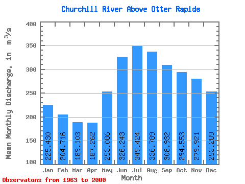
| Statistic | Jan | Feb | Mar | Apr | May | Jun | Jul | Aug | Sep | Oct | Nov | Dec | Annual |
|---|---|---|---|---|---|---|---|---|---|---|---|---|---|
| Mean | 225.43 | 204.72 | 189.10 | 187.26 | 253.09 | 326.24 | 349.42 | 336.79 | 308.93 | 294.55 | 279.92 | 253.29 | 267.45 |
| Standard Deviation | 105.59 | 91.01 | 81.43 | 76.88 | 102.92 | 128.25 | 148.00 | 157.38 | 145.48 | 139.69 | 135.81 | 120.65 | 105.25 |
| Min | 95.20 | 92.00 | 84.40 | 82.00 | 85.20 | 76.00 | 74.70 | 80.20 | 98.50 | 101.00 | 106.00 | 103.00 | 91.43 |
| Max | 472.00 | 421.00 | 370.00 | 370.00 | 622.00 | 790.00 | 864.00 | 883.00 | 761.00 | 689.00 | 604.00 | 524.00 | 609.92 |
| Coefficient of Variation | 0.47 | 0.45 | 0.43 | 0.41 | 0.41 | 0.39 | 0.42 | 0.47 | 0.47 | 0.47 | 0.48 | 0.48 | 0.39 |
 Return to R-Arctic Net Home Page