|
|
|||||||||||||||||
| Point ID: 5583 | Downloads | Plots | Site Data | Code: 06BB005 |
|
|
|||||||||||||||||
| Download | |
|---|---|
| Site Descriptor Information | Site Time Series Data |
| Link to all available data | |
| View: | Time Series | All |
| Units: | mm |
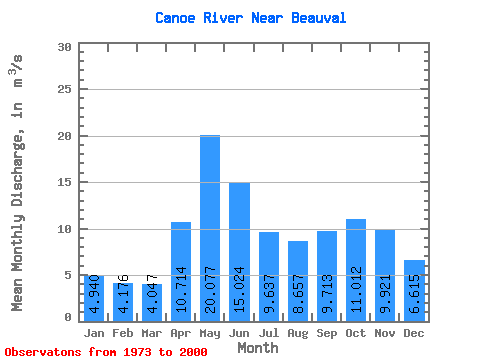
| Statistic | Jan | Feb | Mar | Apr | May | Jun | Jul | Aug | Sep | Oct | Nov | Dec | Annual |
|---|---|---|---|---|---|---|---|---|---|---|---|---|---|
| Mean | 4.94 | 4.18 | 4.05 | 10.71 | 20.08 | 15.02 | 9.64 | 8.66 | 9.71 | 11.01 | 9.92 | 6.62 | 9.32 |
| Standard Deviation | 4.61 | 4.26 | 4.03 | 6.40 | 13.65 | 12.46 | 7.86 | 7.14 | 7.26 | 7.05 | 8.18 | 5.94 | 5.33 |
| Min | 0.01 | 0.00 | 0.00 | 0.72 | 1.60 | 0.80 | 0.57 | 0.69 | 0.82 | 0.77 | 0.35 | 0.06 | 0.69 |
| Max | 22.20 | 20.10 | 19.50 | 30.80 | 61.00 | 48.30 | 28.50 | 23.30 | 27.40 | 25.50 | 39.90 | 29.30 | 24.23 |
| Coefficient of Variation | 0.93 | 1.02 | 0.99 | 0.60 | 0.68 | 0.83 | 0.81 | 0.82 | 0.75 | 0.64 | 0.82 | 0.90 | 0.57 |
 Return to R-Arctic Net Home Page