|
|
|||||||||||||||||
| Point ID: 5581 | Downloads | Plots | Site Data | Code: 06BB003 |
|
|
|||||||||||||||||
| Download | |
|---|---|
| Site Descriptor Information | Site Time Series Data |
| Link to all available data | |
| View: | Time Series | All |
| Units: | mm |
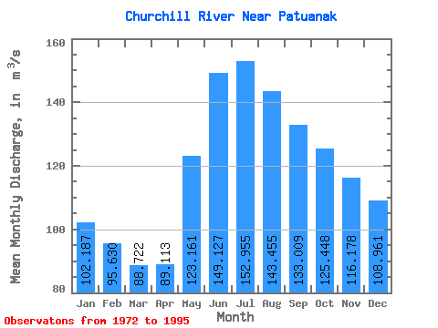
| Statistic | Jan | Feb | Mar | Apr | May | Jun | Jul | Aug | Sep | Oct | Nov | Dec | Annual |
|---|---|---|---|---|---|---|---|---|---|---|---|---|---|
| Mean | 102.19 | 95.63 | 88.72 | 89.11 | 123.16 | 149.13 | 152.96 | 143.46 | 133.01 | 125.45 | 116.18 | 108.96 | 119.90 |
| Standard Deviation | 58.77 | 52.39 | 45.66 | 42.40 | 84.96 | 111.02 | 110.49 | 101.06 | 96.98 | 90.09 | 77.04 | 67.23 | 75.16 |
| Min | 23.90 | 24.10 | 25.40 | 26.50 | 28.00 | 25.30 | 25.20 | 25.40 | 25.50 | 24.80 | 24.90 | 24.50 | 25.67 |
| Max | 253.00 | 222.00 | 193.00 | 192.00 | 448.00 | 577.00 | 569.00 | 501.00 | 465.00 | 429.00 | 357.00 | 304.00 | 372.00 |
| Coefficient of Variation | 0.57 | 0.55 | 0.52 | 0.48 | 0.69 | 0.74 | 0.72 | 0.70 | 0.73 | 0.72 | 0.66 | 0.62 | 0.63 |
 Return to R-Arctic Net Home Page