|
|
|||||||||||||||||
| Point ID: 5578 | Downloads | Plots | Site Data | Code: 06AG002 |
|
|
|||||||||||||||||
| Download | |
|---|---|
| Site Descriptor Information | Site Time Series Data |
| Link to all available data | |
| View: | Time Series | All |
| Units: | mm |
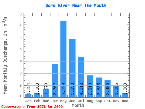
| Statistic | Jan | Feb | Mar | Apr | May | Jun | Jul | Aug | Sep | Oct | Nov | Dec | Annual |
|---|---|---|---|---|---|---|---|---|---|---|---|---|---|
| Mean | 1.25 | 1.39 | 1.67 | 3.76 | 7.30 | 5.85 | 4.31 | 2.81 | 2.63 | 2.48 | 1.91 | 1.38 | 3.10 |
| Standard Deviation | 1.91 | 1.93 | 1.92 | 2.33 | 4.07 | 4.55 | 3.21 | 2.53 | 2.77 | 2.41 | 2.38 | 2.11 | 2.34 |
| Min | 0.00 | 0.00 | 0.00 | 0.27 | 0.43 | 0.10 | 0.14 | 0.05 | 0.05 | 0.26 | 0.20 | 0.03 | 0.60 |
| Max | 8.30 | 7.11 | 6.48 | 8.62 | 16.50 | 21.70 | 12.10 | 11.70 | 11.60 | 8.47 | 8.79 | 8.80 | 10.21 |
| Coefficient of Variation | 1.52 | 1.39 | 1.15 | 0.62 | 0.56 | 0.78 | 0.74 | 0.90 | 1.05 | 0.97 | 1.25 | 1.53 | 0.76 |
 Return to R-Arctic Net Home Page