|
|
|||||||||||||||||
| Point ID: 5565 | Downloads | Plots | Site Data | Code: 06AD003 |
|
|
|||||||||||||||||
| Download | |
|---|---|
| Site Descriptor Information | Site Time Series Data |
| Link to all available data | |
| View: | Time Series | All |
| Units: | mm |
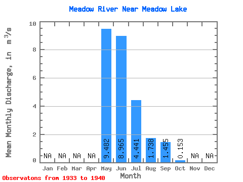
| Statistic | Jan | Feb | Mar | Apr | May | Jun | Jul | Aug | Sep | Oct | Nov | Dec | Annual |
|---|---|---|---|---|---|---|---|---|---|---|---|---|---|
| Mean | 9.48 | 8.96 | 4.44 | 1.74 | 1.46 | 0.15 | |||||||
| Standard Deviation | 10.06 | 17.21 | 6.48 | 2.63 | 2.52 | 0.23 | |||||||
| Min | 0.39 | 0.21 | 0.11 | 0.05 | 0.00 | 0.00 | |||||||
| Max | 30.90 | 51.10 | 18.70 | 7.45 | 6.48 | 0.51 | |||||||
| Coefficient of Variation | 1.06 | 1.92 | 1.46 | 1.52 | 1.73 | 1.47 |
 Return to R-Arctic Net Home Page