|
|
|||||||||||||||||
| Point ID: 5564 | Downloads | Plots | Site Data | Code: 06AD002 |
|
|
|||||||||||||||||
| Download | |
|---|---|
| Site Descriptor Information | Site Time Series Data |
| Link to all available data | |
| View: | Time Series | All |
| Units: | mm |
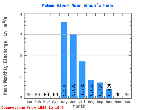
| Statistic | Jan | Feb | Mar | Apr | May | Jun | Jul | Aug | Sep | Oct | Nov | Dec | Annual |
|---|---|---|---|---|---|---|---|---|---|---|---|---|---|
| Mean | 3.60 | 3.01 | 1.73 | 0.87 | 0.74 | 0.42 | |||||||
| Standard Deviation | 3.07 | 4.15 | 1.86 | 0.87 | 1.01 | 0.35 | |||||||
| Min | 0.43 | 0.30 | 0.11 | 0.05 | 0.02 | 0.06 | |||||||
| Max | 9.80 | 13.00 | 5.63 | 2.49 | 3.09 | 0.90 | |||||||
| Coefficient of Variation | 0.85 | 1.38 | 1.08 | 1.00 | 1.38 | 0.84 |
 Return to R-Arctic Net Home Page