|
|
|||||||||||||||||
| Point ID: 5561 | Downloads | Plots | Site Data | Code: 05NF010 |
|
|
|||||||||||||||||
| Download | |
|---|---|
| Site Descriptor Information | Site Time Series Data |
| Link to all available data | |
| View: | Time Series | All |
| Units: | mm |
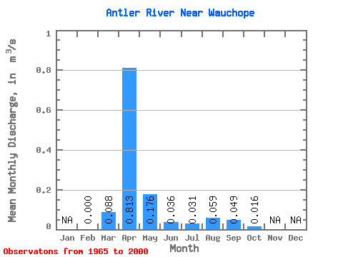
| Statistic | Jan | Feb | Mar | Apr | May | Jun | Jul | Aug | Sep | Oct | Nov | Dec | Annual |
|---|---|---|---|---|---|---|---|---|---|---|---|---|---|
| Mean | 0.00 | 0.09 | 0.81 | 0.18 | 0.04 | 0.03 | 0.06 | 0.05 | 0.02 | ||||
| Standard Deviation | 0.16 | 1.74 | 0.34 | 0.08 | 0.15 | 0.31 | 0.23 | 0.06 | |||||
| Min | 0.00 | 0.00 | 0.00 | 0.00 | 0.00 | 0.00 | 0.00 | 0.00 | 0.00 | ||||
| Max | 0.00 | 0.60 | 9.96 | 1.46 | 0.38 | 0.93 | 1.88 | 1.36 | 0.23 | ||||
| Coefficient of Variation | 1.87 | 2.14 | 1.96 | 2.24 | 4.99 | 5.30 | 4.67 | 3.41 |
 Return to R-Arctic Net Home Page