|
|
|||||||||||||||||
| Point ID: 5556 | Downloads | Plots | Site Data | Code: 05ND010 |
|
|
|||||||||||||||||
| Download | |
|---|---|
| Site Descriptor Information | Site Time Series Data |
| Link to all available data | |
| View: | Time Series | All |
| Units: | mm |
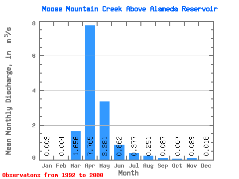
| Statistic | Jan | Feb | Mar | Apr | May | Jun | Jul | Aug | Sep | Oct | Nov | Dec | Annual |
|---|---|---|---|---|---|---|---|---|---|---|---|---|---|
| Mean | 0.00 | 0.00 | 1.66 | 7.76 | 3.38 | 0.86 | 0.38 | 0.25 | 0.09 | 0.07 | 0.09 | 0.02 | 1.21 |
| Standard Deviation | 0.01 | 0.01 | 2.61 | 9.69 | 3.99 | 0.82 | 0.24 | 0.34 | 0.10 | 0.06 | 0.10 | 0.02 | 1.14 |
| Min | 0.00 | 0.00 | 0.00 | 0.32 | 0.07 | 0.02 | 0.04 | 0.00 | 0.00 | 0.00 | 0.00 | 0.00 | 0.19 |
| Max | 0.02 | 0.03 | 7.63 | 25.20 | 10.30 | 2.35 | 0.68 | 0.92 | 0.27 | 0.15 | 0.33 | 0.06 | 3.16 |
| Coefficient of Variation | 2.29 | 3.00 | 1.58 | 1.25 | 1.18 | 0.96 | 0.63 | 1.34 | 1.11 | 0.87 | 1.17 | 1.13 | 0.94 |
 Return to R-Arctic Net Home Page