|
|
|||||||||||||||||
| Point ID: 5554 | Downloads | Plots | Site Data | Code: 05ND004 |
|
|
|||||||||||||||||
| Download | |
|---|---|
| Site Descriptor Information | Site Time Series Data |
| Link to all available data | |
| View: | Time Series | All |
| Units: | mm |
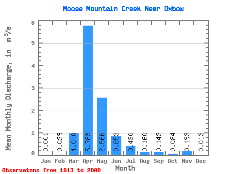
| Statistic | Jan | Feb | Mar | Apr | May | Jun | Jul | Aug | Sep | Oct | Nov | Dec | Annual |
|---|---|---|---|---|---|---|---|---|---|---|---|---|---|
| Mean | 0.00 | 0.03 | 1.01 | 5.78 | 2.57 | 0.85 | 0.43 | 0.16 | 0.14 | 0.08 | 0.19 | 0.01 | 0.91 |
| Standard Deviation | 0.01 | 0.08 | 1.58 | 8.65 | 4.56 | 1.52 | 0.69 | 0.29 | 0.51 | 0.20 | 0.39 | 0.03 | 0.99 |
| Min | 0.00 | 0.00 | 0.00 | 0.00 | 0.00 | 0.00 | 0.00 | 0.00 | 0.00 | 0.00 | 0.00 | 0.00 | 0.00 |
| Max | 0.02 | 0.29 | 7.17 | 51.50 | 22.70 | 8.90 | 3.45 | 1.23 | 3.57 | 1.13 | 1.24 | 0.09 | 3.44 |
| Coefficient of Variation | 3.61 | 2.79 | 1.56 | 1.50 | 1.78 | 1.79 | 1.59 | 1.82 | 3.60 | 2.36 | 2.00 | 2.30 | 1.09 |
 Return to R-Arctic Net Home Page