|
|
|||||||||||||||||
| Point ID: 5553 | Downloads | Plots | Site Data | Code: 05ND003 |
|
|
|||||||||||||||||
| Download | |
|---|---|
| Site Descriptor Information | Site Time Series Data |
| Link to all available data | |
| View: | Time Series | All |
| Units: | mm |
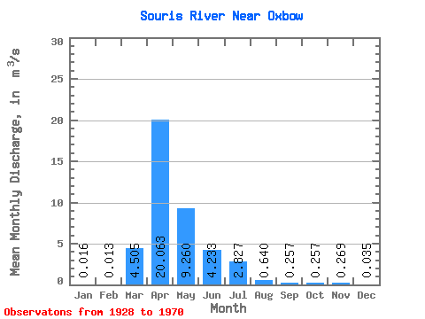
| Statistic | Jan | Feb | Mar | Apr | May | Jun | Jul | Aug | Sep | Oct | Nov | Dec | Annual |
|---|---|---|---|---|---|---|---|---|---|---|---|---|---|
| Mean | 0.02 | 0.01 | 4.50 | 20.06 | 9.26 | 4.23 | 2.83 | 0.64 | 0.26 | 0.26 | 0.27 | 0.04 | 2.78 |
| Standard Deviation | 0.03 | 0.02 | 6.24 | 25.47 | 14.35 | 6.09 | 5.50 | 0.92 | 0.32 | 0.39 | 0.58 | 0.05 | 3.46 |
| Min | 0.00 | 0.00 | 0.13 | 0.08 | 0.14 | 0.06 | 0.00 | 0.00 | 0.00 | 0.00 | 0.00 | 0.00 | 0.11 |
| Max | 0.07 | 0.05 | 24.50 | 103.00 | 56.50 | 29.80 | 28.50 | 3.66 | 1.41 | 1.55 | 2.08 | 0.15 | 11.13 |
| Coefficient of Variation | 1.57 | 1.39 | 1.39 | 1.27 | 1.55 | 1.44 | 1.95 | 1.44 | 1.22 | 1.50 | 2.15 | 1.54 | 1.25 |
 Return to R-Arctic Net Home Page