|
|
|||||||||||||||||
| Point ID: 5526 | Downloads | Plots | Site Data | Code: 05NB009 |
|
|
|||||||||||||||||
| Download | |
|---|---|
| Site Descriptor Information | Site Time Series Data |
| Link to all available data | |
| View: | Time Series | All |
| Units: | mm |
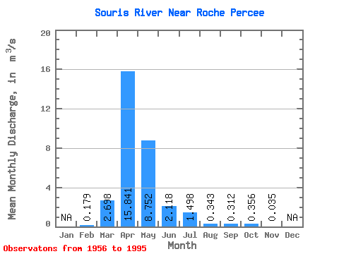
| Statistic | Jan | Feb | Mar | Apr | May | Jun | Jul | Aug | Sep | Oct | Nov | Dec | Annual |
|---|---|---|---|---|---|---|---|---|---|---|---|---|---|
| Mean | 0.18 | 2.70 | 15.84 | 8.75 | 2.12 | 1.50 | 0.34 | 0.31 | 0.36 | 0.04 | |||
| Standard Deviation | 0.33 | 5.48 | 28.24 | 18.51 | 4.78 | 3.21 | 0.56 | 0.68 | 0.68 | ||||
| Min | 0.00 | 0.01 | 0.03 | 0.01 | 0.00 | 0.00 | 0.00 | 0.00 | 0.00 | 0.04 | |||
| Max | 0.68 | 24.50 | 132.00 | 78.60 | 25.60 | 16.80 | 2.03 | 3.14 | 3.08 | 0.04 | |||
| Coefficient of Variation | 1.86 | 2.03 | 1.78 | 2.12 | 2.26 | 2.14 | 1.63 | 2.19 | 1.92 |
 Return to R-Arctic Net Home Page