|
|
|||||||||||||||||
| Point ID: 5520 | Downloads | Plots | Site Data | Code: 05NA005 |
|
|
|||||||||||||||||
| Download | |
|---|---|
| Site Descriptor Information | Site Time Series Data |
| Link to all available data | |
| View: | Time Series | All |
| Units: | mm |
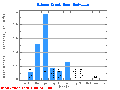
| Statistic | Jan | Feb | Mar | Apr | May | Jun | Jul | Aug | Sep | Oct | Nov | Dec | Annual |
|---|---|---|---|---|---|---|---|---|---|---|---|---|---|
| Mean | 0.12 | 0.52 | 0.94 | 0.17 | 0.13 | 0.26 | 0.01 | 0.01 | 0.00 | ||||
| Standard Deviation | 0.08 | 0.94 | 1.47 | 0.42 | 0.32 | 0.90 | 0.04 | 0.05 | 0.01 | ||||
| Min | 0.06 | 0.00 | 0.00 | 0.00 | 0.00 | 0.00 | 0.00 | 0.00 | 0.00 | ||||
| Max | 0.17 | 4.12 | 5.16 | 1.96 | 1.72 | 5.24 | 0.26 | 0.32 | 0.03 | ||||
| Coefficient of Variation | 0.71 | 1.81 | 1.56 | 2.49 | 2.45 | 3.48 | 4.21 | 5.73 | 6.08 |
 Return to R-Arctic Net Home Page