|
|
|||||||||||||||||
| Point ID: 5512 | Downloads | Plots | Site Data | Code: 05MD004 |
|
|
|||||||||||||||||
| Download | |
|---|---|
| Site Descriptor Information | Site Time Series Data |
| Link to all available data | |
| View: | Time Series | All |
| Units: | mm |
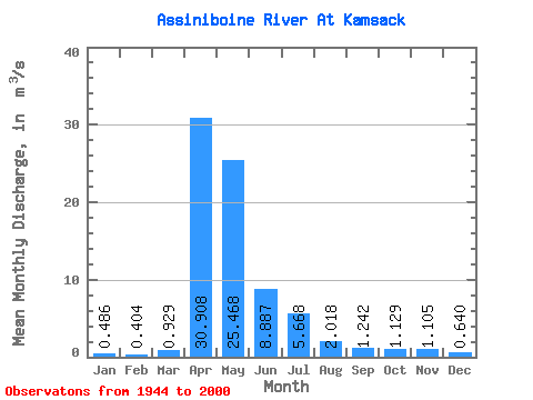
| Statistic | Jan | Feb | Mar | Apr | May | Jun | Jul | Aug | Sep | Oct | Nov | Dec | Annual |
|---|---|---|---|---|---|---|---|---|---|---|---|---|---|
| Mean | 0.49 | 0.40 | 0.93 | 30.91 | 25.47 | 8.89 | 5.67 | 2.02 | 1.24 | 1.13 | 1.10 | 0.64 | 5.85 |
| Standard Deviation | 0.56 | 0.45 | 1.11 | 28.76 | 33.20 | 16.73 | 10.32 | 4.78 | 2.97 | 2.26 | 1.60 | 0.67 | 5.34 |
| Min | 0.00 | 0.00 | 0.01 | 0.63 | 0.72 | 0.36 | 0.00 | 0.00 | 0.00 | 0.00 | 0.00 | 0.00 | 0.18 |
| Max | 2.47 | 2.36 | 5.16 | 144.00 | 132.00 | 118.00 | 62.80 | 31.30 | 12.80 | 13.50 | 7.81 | 3.08 | 28.26 |
| Coefficient of Variation | 1.16 | 1.11 | 1.20 | 0.93 | 1.30 | 1.88 | 1.82 | 2.37 | 2.39 | 2.00 | 1.45 | 1.05 | 0.91 |
 Return to R-Arctic Net Home Page