|
|
|||||||||||||||||
| Point ID: 5510 | Downloads | Plots | Site Data | Code: 05MC003 |
|
|
|||||||||||||||||
| Download | |
|---|---|
| Site Descriptor Information | Site Time Series Data |
| Link to all available data | |
| View: | Time Series | All |
| Units: | mm |
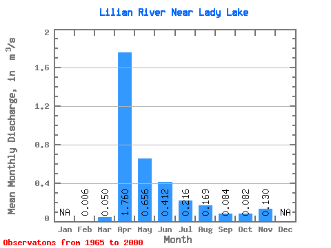
| Statistic | Jan | Feb | Mar | Apr | May | Jun | Jul | Aug | Sep | Oct | Nov | Dec | Annual |
|---|---|---|---|---|---|---|---|---|---|---|---|---|---|
| Mean | 0.01 | 0.05 | 1.76 | 0.66 | 0.41 | 0.22 | 0.17 | 0.08 | 0.08 | 0.13 | |||
| Standard Deviation | 0.07 | 1.33 | 0.76 | 0.54 | 0.27 | 0.50 | 0.21 | 0.10 | 0.14 | ||||
| Min | 0.01 | 0.00 | 0.20 | 0.06 | 0.01 | 0.01 | 0.00 | 0.00 | 0.00 | 0.03 | |||
| Max | 0.01 | 0.25 | 4.89 | 2.68 | 2.07 | 1.13 | 2.18 | 1.10 | 0.49 | 0.23 | |||
| Coefficient of Variation | 1.37 | 0.76 | 1.15 | 1.30 | 1.23 | 2.97 | 2.44 | 1.17 | 1.05 |
 Return to R-Arctic Net Home Page