|
|
|||||||||||||||||
| Point ID: 5508 | Downloads | Plots | Site Data | Code: 05MC001 |
|
|
|||||||||||||||||
| Download | |
|---|---|
| Site Descriptor Information | Site Time Series Data |
| Link to all available data | |
| View: | Time Series | All |
| Units: | mm |
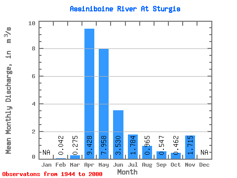
| Statistic | Jan | Feb | Mar | Apr | May | Jun | Jul | Aug | Sep | Oct | Nov | Dec | Annual |
|---|---|---|---|---|---|---|---|---|---|---|---|---|---|
| Mean | 0.04 | 0.28 | 9.43 | 7.96 | 3.53 | 1.78 | 0.96 | 0.55 | 0.46 | 1.71 | |||
| Standard Deviation | 0.32 | 8.07 | 9.96 | 6.78 | 3.81 | 2.76 | 1.46 | 1.04 | 0.05 | ||||
| Min | 0.04 | 0.00 | 0.30 | 0.23 | 0.03 | 0.00 | 0.00 | 0.00 | 0.00 | 1.68 | |||
| Max | 0.04 | 1.47 | 31.50 | 36.00 | 44.60 | 26.60 | 14.80 | 7.01 | 6.68 | 1.75 | |||
| Coefficient of Variation | 1.15 | 0.86 | 1.25 | 1.92 | 2.13 | 2.86 | 2.67 | 2.26 | 0.03 |
 Return to R-Arctic Net Home Page