|
|
|||||||||||||||||
| Point ID: 5499 | Downloads | Plots | Site Data | Code: 05MB002 |
|
|
|||||||||||||||||
| Download | |
|---|---|
| Site Descriptor Information | Site Time Series Data |
| Link to all available data | |
| View: | Time Series | All |
| Units: | mm |
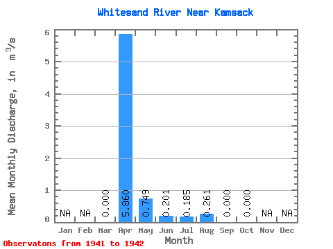
| Statistic | Jan | Feb | Mar | Apr | May | Jun | Jul | Aug | Sep | Oct | Nov | Dec | Annual |
|---|---|---|---|---|---|---|---|---|---|---|---|---|---|
| Mean | 0.00 | 5.86 | 0.75 | 0.20 | 0.18 | 0.26 | 0.00 | 0.00 | |||||
| Standard Deviation | 3.03 | 0.16 | 0.08 | 0.26 | 0.37 | ||||||||
| Min | 0.00 | 3.72 | 0.64 | 0.15 | 0.00 | 0.00 | 0.00 | 0.00 | |||||
| Max | 0.00 | 8.00 | 0.86 | 0.26 | 0.37 | 0.52 | 0.00 | 0.00 | |||||
| Coefficient of Variation | 0.52 | 0.21 | 0.39 | 1.41 | 1.41 |
 Return to R-Arctic Net Home Page