|
|
|||||||||||||||||
| Point ID: 548 | Downloads | Plots | Site Data | Code: 05FC005 |
|
|
|||||||||||||||||
| Download | |
|---|---|
| Site Descriptor Information | Site Time Series Data |
| Link to all available data | |
| View: | Time Series | All |
| Units: | mm |
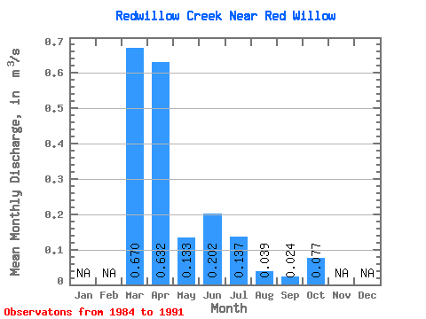
| Statistic | Jan | Feb | Mar | Apr | May | Jun | Jul | Aug | Sep | Oct | Nov | Dec | Annual |
|---|---|---|---|---|---|---|---|---|---|---|---|---|---|
| Mean | 0.67 | 0.63 | 0.13 | 0.20 | 0.14 | 0.04 | 0.02 | 0.08 | |||||
| Standard Deviation | 0.90 | 0.60 | 0.06 | 0.46 | 0.26 | 0.05 | 0.04 | 0.09 | |||||
| Min | 0.00 | 0.06 | 0.04 | 0.01 | 0.00 | 0.01 | 0.00 | 0.00 | |||||
| Max | 2.02 | 1.80 | 0.24 | 1.14 | 0.66 | 0.15 | 0.10 | 0.18 | |||||
| Coefficient of Variation | 1.34 | 0.95 | 0.46 | 2.27 | 1.88 | 1.30 | 1.54 | 1.14 |
 Return to R-Arctic Net Home Page