|
|
|||||||||||||||||
| Point ID: 5477 | Downloads | Plots | Site Data | Code: 05LC001 |
|
|
|||||||||||||||||
| Download | |
|---|---|
| Site Descriptor Information | Site Time Series Data |
| Link to all available data | |
| View: | Time Series | All |
| Units: | mm |
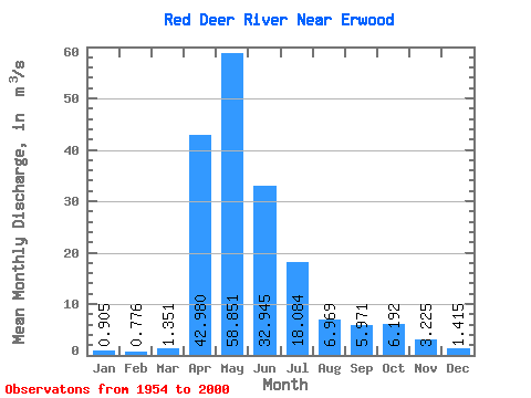
| Statistic | Jan | Feb | Mar | Apr | May | Jun | Jul | Aug | Sep | Oct | Nov | Dec | Annual |
|---|---|---|---|---|---|---|---|---|---|---|---|---|---|
| Mean | 0.91 | 0.78 | 1.35 | 42.98 | 58.85 | 32.95 | 18.08 | 6.97 | 5.97 | 6.19 | 3.23 | 1.42 | 13.07 |
| Standard Deviation | 0.54 | 0.56 | 1.38 | 30.82 | 58.10 | 46.00 | 19.11 | 9.65 | 10.84 | 7.72 | 2.20 | 0.85 | 7.89 |
| Min | 0.05 | 0.00 | 0.00 | 4.01 | 5.28 | 1.31 | 0.14 | 0.07 | 0.02 | 0.25 | 0.28 | 0.10 | 2.63 |
| Max | 2.20 | 2.20 | 6.89 | 105.00 | 232.00 | 288.00 | 78.20 | 48.20 | 71.30 | 51.00 | 9.61 | 3.62 | 29.27 |
| Coefficient of Variation | 0.60 | 0.72 | 1.02 | 0.72 | 0.99 | 1.40 | 1.06 | 1.38 | 1.82 | 1.25 | 0.68 | 0.60 | 0.60 |
 Return to R-Arctic Net Home Page