|
|
|||||||||||||||||
| Point ID: 5471 | Downloads | Plots | Site Data | Code: 05LB005 |
|
|
|||||||||||||||||
| Download | |
|---|---|
| Site Descriptor Information | Site Time Series Data |
| Link to all available data | |
| View: | Time Series | All |
| Units: | mm |
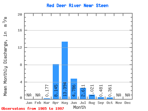
| Statistic | Jan | Feb | Mar | Apr | May | Jun | Jul | Aug | Sep | Oct | Nov | Dec | Annual |
|---|---|---|---|---|---|---|---|---|---|---|---|---|---|
| Mean | 0.18 | 8.14 | 13.39 | 4.79 | 2.61 | 1.02 | 0.48 | 0.36 | |||||
| Standard Deviation | 0.17 | 6.67 | 15.19 | 5.21 | 3.37 | 1.44 | 0.76 | 0.41 | |||||
| Min | 0.00 | 0.15 | 0.11 | 0.04 | 0.02 | 0.00 | 0.00 | 0.00 | |||||
| Max | 0.68 | 22.90 | 50.10 | 22.70 | 15.90 | 5.63 | 3.00 | 1.50 | |||||
| Coefficient of Variation | 0.95 | 0.82 | 1.13 | 1.09 | 1.29 | 1.41 | 1.57 | 1.12 |
 Return to R-Arctic Net Home Page